
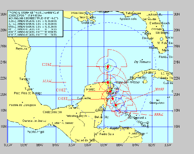
Much as we expected, the Gulf/Western Caribbean Hurricane has been much more active this year, first spawning a couple of weak Cat One storms and now Keith, a quintessential horror story of a storm. What makes Keith such a frightening prospect is the lack of steering currents which has had it barely drifting at 2kts for the last 48 hours. 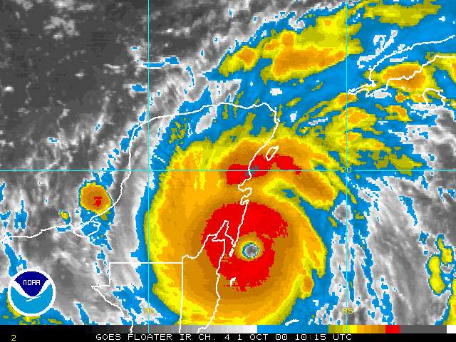 Keith as of 10-01-00, 0800 Slow moving storms like this offer up the worst possible scenario because of the long period of time in which the worst of the effects are experienced. It's one thing to have hurricane conditions for 6 hours, something else again for hurricane conditions to last 12 hours or more. The coastal Yucatan Peninsula just south of Cozumel has been bearing the brunt of the storm now for close to 24 hours. This is likely a tragedy of major proportions for local residents as staggering rainfall rates are generated by the barely moving storm. Combined with 100+kt. winds for duration periods exceeding 12 hours, the effects on people as well as property will be awesome. Slow moving storms like this present the worst case scenario for hurricanes. The prognosis for Keith is a northerly track, taking it up the Yucatan coast line and over Cozumel. As of this writing the eye is about to go ashore, and gradual weakening will occur. Despite this, the burgeoning tourist resort of Cancun will still be hit hard. All Marine interests on the CONUS Gulf coast should pay close attention to this storm. It will likely be Tuesday or Wednesday before Keith emerges into the Gulf. The problem here is that at this point, the storm's track is basically unpredictable. If the storm's northerly movement remains as slow as it is, it will emerge off the Yucatan coastline greatly weakened. Current predictions have it coming off land still at hurricane force. Once in the Gulf, it is expected to rapidly regain strength. Where it goes after that is anyone's guess, but as of the moment, the central Gulf appears to be the most likely target. Once entering the Gulf. the forward speed is expected to increase. This yields a probable CONUS landfall window of around Friday-Saturday. Boat owners throughout the Gulf region now have plenty of advance warning to get prepared. Joyce The Cape Verde season threw little at us this year, but TS Joyce, now situated near Trinidad, which nearly died out yesterday, is again resuming strength as it enters a somewhat more favorable area. Joyce took on more northwesterly course, just enough to keep her from slamming into S. America. Her current direction is slightly north of west and, as with Keith, it's course over the next few days remains uncertain. Despite the fact that the official hurricane season is nearly a close, this season is not yet over by any means. Yet another western Caribbean storm could develop in the wake of Keith, as conditions remain highly favorable for storm development.
|
Keith Reaches Category 4 Status
140MPH Winds as of 0600
10/1/00
by David Pascoe
David Pascoe - Biography

Buying, Owning, Maintaining a Boat or Yacht.
Over 160 articles by David Pascoe.
Boat Reviews Buying a Boat Hull Blisters Cores & Structural Issues Insurance Issues Marine Engines Maintenance, Repairs & Troubleshooting Boat Handling & Boat Safety Hurricane Preparations Marine Surveying All Online Articles David Pascoe's
Power Boat Books  Mid Size Power Boats
A Guide for Discriminating Buyers
Focuses exclusively cruiser class generally 30-55 feet
With discussions on the pros and cons of each type: Expresses, trawlers, motor yachts, multi purpose types, sportfishermen and sedan cruisers.
 Buyers' Guide to Outboard Boats
Selecting and Evaluating New and Used Boats
Dedicated for offshore outboard boats
A hard and realistic look at the marine market place and delves into issues of boat quality and durability that most other marine writers are unwilling to touch.
 Surveying Fiberglass Power Boats
2nd Edition
The Art of Pre-Purchase Survey The very first of its kind, this book provides the essentials that every novice needs to know, as well as a wealth of esoteric details.
 Marine Investigations
Pleasure crafts investigations to court testimony The first and only book of its kind on the subject of investigating pleasure craft casualties and other issues.
Power Boat Books
Mid Size Power Boats A Guide for Discriminating Buyers
Focuses exclusively cruiser class generally 30-55 feet
With discussions on the pros and cons of each type: Expresses, trawlers, motor yachts, multi purpose types, sportfishermen and sedan cruisers.
Selecting and Evaluating New and Used Boats
Dedicated for offshore outboard boats
A hard and realistic look at the marine market place and delves into issues of boat quality and durability that most other marine writers are unwilling to touch.
2nd Edition
The Art of Pre-Purchase Survey The very first of its kind, this book provides the essentials that every novice needs to know, as well as a wealth of esoteric details.
Pleasure crafts investigations to court testimony The first and only book of its kind on the subject of investigating pleasure craft casualties and other issues.

David Pascoe is a second generation marine surveyor in his family who began his surveying career at age 16 as an apprentice in 1965 as the era of wooden boats was drawing to a close.
Certified by the National Association of Marine Surveyors in 1972, he has conducted over 5,000 pre purchase surveys in addition to having conducted hundreds of boating accident investigations, including fires, sinkings, hull failures and machinery failure analysis.
Over forty years of knowledge and experience are brought to bear in following books. David Pascoe is the author of:
In addition to readers in the United States, boaters and boat industry professionals worldwide from nearly 80 countries have purchased David Pascoe's books, since introduction of his first book in 2001.
In 2012, David Pascoe has retired from marine surveying business at age 65.
On November 23rd, 2018, David Pascoe has passed away at age 71.
Biography - Long version